This document describes an application profile, in this case NeTEx Belgium: Stop Places (application profile). The application profile specifies a semantic data model covering a set of use cases. The specification consists of terms with their constraints (cardinalities, codelists, usage guidelines).
Summary
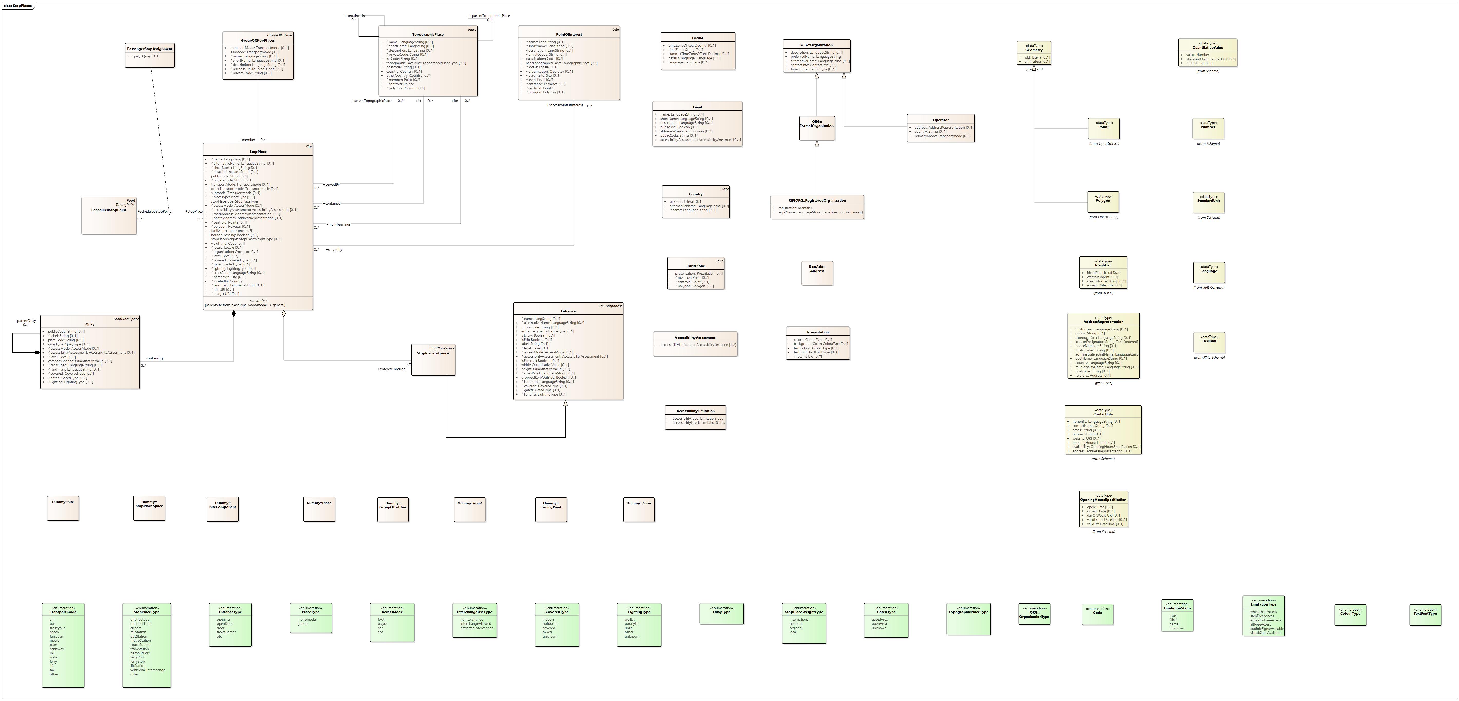
The application profile NETEX Belgium – Stop Places describes how the terms from the corresponding vocabulary should be used to describe physical stops and their link to the logical stops in a public transport network.
The standard is based on the EPIP profile on NETEX.
Use case here is to describe stop place infrastructure, stop place plans and route planning based on stations, POIs or topographical places.
The Scheduled Stop Point class (discussed more extensively in NETEX Belgium - Timetables) describes the points where Lines stop when performing a Service Journey. They are the logical stops of a Network, the points where you can get off the bus, but also from which other stops in the Network can be reached or from which you can transfer to stops of an overlapping Network.
Physically, these stops realize themselves as a Stop Place, so this class represents the physical stops. This can range from stop posts or shelters to complete stations with several floors for different modes of transport.
Both classes are interconnected, typical case is the multimodal situation where each Network has its own Scheduled Stopping Points even if they coincide spatially (eg a Stop Place where both buses and trams stop). Via the Stop Place – Scheduled Stop Point relationship you can check which public transport services you can consume at the physical stop.
It is assumed that all Scheduled Stop Points (logical stops) within a Stop Place (physical stop) are within walking distance of each other, in other words that implicit transfers are possible between the logical stops of a Stop Place. The model currently does not allow to explicitly describe these connections.
The advantage of Stop Place is also that the physical side of the stop infrastructure can be described separately from the description of the Network's topology. Classes such as Quay and Stop Place Entrance are provided, among others. It is also possible to directly link Scheduled Stop Points with Quays.
A Stop Place is also a Site and thanks to the self-association of Stop Place a hierarchy of Stop Places can be elaborated. EPIP allows 3 levels: General (multimodal), Monomodal and Quay. Group Of Stop Places also allows you to group similar Stop Places, eg according to their location (eg all metro stations in Brussels).
Finally, we mention supporting classes such as Point Of Interest and Topographic Place (which allow you to plan a trip without knowing stop names).
The code lists in the diagram are merely illustrative. The lists are sometimes incomplete (indicated by the value etc at the end of the list). The values provided are not necessarily those that will be used in an implementation.
Status of this document
This application profile has the status of Recommended Standard published on 2023-10-24.
Information about the process and the decisions involved in the creation of this specification are consultable at the registry of standards.
License
This specification of Digitaal Vlaanderen is published under "Model license Free Reuse - v1.0".
Conformance
An implementation is conformant with this application profile if it satisfies these rules.
Overview
This document describes the usage of the following entities for a correct usage of the Application Profile:
|
Accessibility Assessment |
AccessibilityLimitation |
Address |
Country |
Entrance |
Formal Organization |
Group of Entities |
Group of Stop Places |
Level |
Locale |
Operator |
Organization |
Passenger Stop Assignment |
Place |
Point (Class) |
Point of Interest |
Presentation |
Quay |
Registered Organization |
Scheduled Stop Point |
Site |
Site Component |
Stop Place |
Stop Place Entrance |
Stop Place Space |
Tariff Zone |
Timing Point |
Topographic Place |
Zone |
This document describes the usage of the following datatypes for a correct usage of the Application Profile:
|
Address Representation |
Contact Info |
Decimal |
Geometry |
Identifier |
Language |
Number |
Opening Hours Specification |
Point (Datatype) |
Polygon |
Quantitative Value |
Standard Unit |
Entities
Accessibility Assessment
- Description
- The accessibility characteristics of an entity used by passengers such as a Stop Place.
- Properties
- For this entity the following properties are defined: accessibilityLimitation.
| Property | Expected Range | Cardinality | Description | Usage | Codelist |
|---|---|---|---|---|---|
accessibilityLimitation
|
AccessibilityLimitation | 1..* | Reference to an AccessibilityLimitation making up the AccessibilityAssessment. |
AccessibilityLimitation
- Description
- Describes the usability of an entity for passengers with certain needs.
- Properties
- For this entity the following properties are defined: accessibilityLevel, accessibilityType.
| Property | Expected Range | Cardinality | Description | Usage | Codelist |
|---|---|---|---|---|---|
accessibilityLevel
|
LimitationStatus | 1 | Level of usability. | ||
accessibilityType
|
LimitationType | 1 | Type of usability. | Eg accessible by wheelchair, escalator free access etc. |
Address
- Description
- Information that makes it possible to refer in a structured and unique way to a building unit, a berth, a location or a plot on the basis of a municipality name, a street name, a house number and possibly a bus number and a postal code.
- Usage
- The definition refers to Belgian Addresses. In other countries, an Address may refer to other geographical objects (not a building unit or parcel) or may consist of other designations (different from house number and bus number) or of components other than street name, municipality name or postal code. Foreign addresses can be exchanged using the Address Representation object. More detail on this class in the INSPRE Address specification.
- Properties
- No properties have been defined for this entity.
Country
- Description
- A jurisdictional geographic boundary.
- Subclass of
- Place
- Properties
- For this entity the following properties are defined: alternative name, name, UIC code.
| Property | Expected Range | Cardinality | Description | Usage | Codelist |
|---|---|---|---|---|---|
alternative name
|
LanguageString | 0..* | Alternative name for the Country. | ||
name
|
LanguageString | 0..1 | Name of the Country. | ||
UIC code
|
Literal | 0..1 | UIC code of the Country. |
Entrance
- Description
- Physical entrance or exit to/from a Site.
- Usage
- May be a door, barrier, gate or other recognisable point of access.
- Subclass of
- Site Component
- Properties
- For this entity the following properties are defined: access mode, accessibility assessment, alternative name, covered, cross road, dropped kerb outside, entrance type, gated, height, is entry, is exit, is external, label, landmark, level, lighting, name, public code, width.
| Property | Expected Range | Cardinality | Description | Usage | Codelist |
|---|---|---|---|---|---|
access mode
|
Access Mode | 0..* | Access modes of the Entrance. | ||
accessibility assessment
|
Accessibility Assessment | 0..1 | Accessibility of the Entrance. | ||
alternative name
|
LanguageString | 0..* | Alternative name for the Site Entrance. | ||
covered
|
Covered Type | 0..1 | Indicates whether the Entrance is covered of outdoors. | ||
cross road
|
LanguageString | 0..1 | Name of nearest cross road or crossing street on which site is and which can be used to locate the Entrance. | Mainly relevant for bus modes, where the cross road may provide necessary context to describe the stop to a user. | |
dropped kerb outside
|
Boolean | 0..1 | Indicates whether there is a drobbed kerb outside the Site Entrance. | ||
entrance type
|
Entrance Type | 0..1 | Type of Site Entrance. | ||
gated
|
Gated Type | 0..1 | Indicates whether the Entrance is within a gated area. | ||
height
|
Quantitative Value | 0..1 | Height of the Entrance. | ||
is entry
|
Boolean | 0..1 | Indicates whether the Entrance can be used for entry to the Stop Place. | ||
is exit
|
Boolean | 0..1 | Indicates whether the Entrance can be used for exit from the Stop Place. | ||
is external
|
Boolean | 0..1 | Indicates whether the Site Entrance opens externally. | ||
label
|
String | 0..1 | Label of the Entrance. | ||
landmark
|
LanguageString | 0..1 | Name of a nearby Landmark. | ||
level
|
Level | 0..1 | Level of the Entrance. | ||
lighting
|
Lighting Type | 0..1 | Indicates how the Entrance is lit. | ||
name
|
LangString | 0..1 | Name of theEntrance. | ||
public code
|
String | 0..1 | Public code for the Site Entrance. | ||
width
|
Quantitative Value | 0..1 | Width of the Entrance. |
Formal Organization
- Description
- A recognized organization, recognized in a broad sense or more specifically in a legal sense, with associated rights and obligations.
- Usage
- Eg a company, a non-profit organization, a government body, a church community.
- Subclass of
- Organization
- Properties
- No properties have been defined for this entity.
Group of Entities
- Description
- A set of Entities grouped together according to a purpose of grouping, e.g. grouping of stops known to the public by a common name.
- Properties
- No properties have been defined for this entity.
Group of Stop Places
- Description
- A grouping of Stop Places which will be commonly referenced for a specific purpose (stops inside an airport, main stops of a city, etc.).
- Subclass of
- Group of Entities
- Properties
- For this entity the following properties are defined: description, member, name, private code, purpose of grouping, short name, submode, transport mode.
| Property | Expected Range | Cardinality | Description | Usage | Codelist |
|---|---|---|---|---|---|
description
|
LanguageString | 0..1 | Description of the Group of Stop Places. | ||
member
|
Stop Place | 0..* | Stop Place that belongs to the Group of Stop Places. | ||
name
|
LanguageString | 0..1 | Name of the Group of Stop Places. | ||
private code
|
String | 0..1 | Private code associated with the Group of Stop Places. | ||
purpose of grouping
|
Code | 0..1 | Purpose of grouping the Stop Places. | ||
short name
|
LanguageString | 0..1 | Short name for the Group of Stop Places. | ||
submode
|
Transportmode | 0..1 | Submode of the Group of Stop Places | ||
transport mode
|
Transportmode | 0..1 | Transport mode of the Group of Stop Places. |
Level
- Description
- An identified storey (ground, first, basement, mezzanine, etc) within an interchange building or Site on which Site Components reside.
- Properties
- For this entity the following properties are defined: accessiblilty assessment, all areas wheelchair, description, name, public code, public use, short name.
| Property | Expected Range | Cardinality | Description | Usage | Codelist |
|---|---|---|---|---|---|
accessiblilty assessment
|
Accessibility Assessment | 0..1 | Accessibility of the Level. | ||
all areas wheelchair
|
Boolean | 0..1 | Indicates whether all areas of the Level are wheelchair accessible. | ||
description
|
LanguageString | 0..1 | Description of the Level. | ||
name
|
LanguageString | 0..1 | Name of the Level. | ||
public code
|
String | 0..1 | Public code of the Level. | ||
public use
|
Boolean | 0..1 | Indicates whether the Level is for public use. | ||
short name
|
LanguageString | 0..1 | Short name for the Level. |
Locale
- Description
- Parameters and properties to be used when processing and presenting data in a country or region (time zone, language, etc.).
- Properties
- For this entity the following properties are defined: default language, language, summer time zone offset, time zone, time zone offset.
| Property | Expected Range | Cardinality | Description | Usage | Codelist |
|---|---|---|---|---|---|
default language
|
Language | 0..1 | Default language of the Locale, e.g. en, fr, de, etc. | ||
language
|
Language | 0..* | Other languages supported in the Locale. | ||
summer time zone offset
|
Decimal | 0..1 | Time zone as an offset in hours or part hours from GMT. | Can be plus or minus. | |
time zone
|
String | 0..1 | Name of the time zone associated with the Locale. | ||
time zone offset
|
Decimal | 0..1 | Time zone of the Locale as offset in hours from GMT. | Can be plus, or minus. May be decimal for fractional differences. |
Operator
- Description
- A company providing public transport services.
- Subclass of
- Organization
- Properties
- For this entity the following properties are defined: address, country, primary mode.
| Property | Expected Range | Cardinality | Description | Usage | Codelist |
|---|---|---|---|---|---|
address
|
Address Representation | 0..1 | Postal address of the Operator. | ||
country
|
String | 0..1 | Reference to the Country. | ||
primary mode
|
Transportmode | 0..1 | Primary Transport Mode of the Operator. |
Organization
- Description
- A number of people organized into a community or other social, commercial, or political structure. The group has a common purpose or raison d'être that transcends its individual members and it can act as an agent. An organization often has a hierarchical structure.
- Usage
- More details on this class in the W3C Organization Ontology.
- Properties
- For this entity the following properties are defined: alternative name, contactinfo, description, preferred name, type.
| Property | Expected Range | Cardinality | Description | Usage | Codelist |
|---|---|---|---|---|---|
alternative name
|
LanguageString | 0..* | Other name by which the organization is known. | E.g. commercial name, informal name | |
contactinfo
|
Contact Info | 0..* | Information such as email, telephone... that allows to contact the Organization. | ||
description
|
LanguageString | 0..1 | Description of the Organization. | ||
preferred name
|
LanguageString | 1 | Name by which the organization is preferably indicated. | ||
type
|
OrganizationType | 0..* | Type of Organization. | Specialization of classification (besides activity & status). |
Passenger Stop Assignment
- Description
- The allocation of a Scheduled Stop Point to a Stop Place.
- Properties
- For this entity the following properties are defined: Gepland Stoppunt, quay, Stopplaats.
| Property | Expected Range | Cardinality | Description | Usage | Codelist |
|---|---|---|---|---|---|
Gepland Stoppunt
|
Scheduled Stop Point | 1 | Referentie naar verbonden klasse. | ||
quay
|
Quay | 0..1 | Reference to a Quay within the Stop Place to which the Scheduled Stop Point is assigned. | ||
Stopplaats
|
Stop Place | 1 | Referentie naar verbonden klasse. |
Place
- Description
- Topographically significant location that a transport model may wish to describe.
- Properties
- No properties have been defined for this entity.
Point (Class)
- Description
- A 0-dimensional node of the Network used for the spatial description of the Network. Points may be located by a Location in a given Locating System.
- Properties
- No properties have been defined for this entity.
Point of Interest
- Description
- A type of Place to or through which passengers may wish to navigate as part of their journey and which is modelled in detail by route planners.
- Subclass of
- Site
- Properties
- For this entity the following properties are defined: centroid, classification, description, entrance, level, locale, name, near topographic place, organisation, parent site, polygon, private code, served by, short name.
| Property | Expected Range | Cardinality | Description | Usage | Codelist |
|---|---|---|---|---|---|
centroid
|
Point (Datatype) | 1 | Centre Point of the Topographic Place. | ||
classification
|
Code | 0..* | Classification of the Point of Interest. | ||
description
|
LangString | 0..1 | Description of the Point of Interest. | ||
entrance
|
Entrance | 0..* | Entrance to the Point of Interest. | ||
level
|
Level | 0..* | Level of the Point of Interest. | ||
locale
|
Locale | 0..1 | Locale setting time zone, default language, etc., for the Point of Interest. | ||
name
|
LangString | 0..1 | Name of the Point of Interest. | ||
near topographic place
|
Topographic Place | 0..* | Topographic Places near the Point of Interest. | ||
organisation
|
Operator | 0..1 | Reference to the Operator of the Point of Interest. | ||
parent site
|
Site | 0..1 | Parent Site which contains the Point of Interest. | ||
polygon
|
Polygon | 0..1 | Polygon associated with the Point of Interest. | ||
private code
|
String | 0..1 | Private code of the Point of Interest. | ||
served by
|
Stop Place | 0..* | Point of Interest served by the Stop Place. | ||
short name
|
LangString | 0..1 | Short name of the Point of Interest. |
Presentation
- Description
- Defines a uniform set of values to control appearances of an element (on a map, a schematic map, a paper or screen description, etc.).
- Properties
- For this entity the following properties are defined: backgroundColour, colour, infoLink, textColour, textFont.
| Property | Expected Range | Cardinality | Description | Usage | Codelist |
|---|---|---|---|---|---|
backgroundColour
|
ColourType | 0..1 | Default RGB background colour value for graphics associated with an entity. | ||
colour
|
ColourType | 0..1 | RGB colour value to use for an entity in the user interface. | Eg the colour of a Line. | |
infoLink
|
URI | 0..* | URL of an image associated with the entity. | Eg an icon. | |
textColour
|
ColourType | 0..1 | Colour value to use forthe text of an entity in the user interface. | Eg he colour of the name of a Line. | |
textFont
|
TextFontType | 0..1 | Font of the tekst. |
Quay
- Description
- A place such as a platform, bus stop, stance or quay side where passengers have access to public transport vehicles, taxi, cars or other means of transportation.
- Subclass of
- Stop Place Space
- Properties
- For this entity the following properties are defined: access mode, accessibility assessment, compass bearing, covered, cross road, gated, label, level, lighting, parent quay, plate code, public code, quay type.
| Property | Expected Range | Cardinality | Description | Usage | Codelist |
|---|---|---|---|---|---|
access mode
|
Access Mode | 0..* | Access mode of the Quay. | ||
accessibility assessment
|
Accessibility Assessment | 0..1 | Accessibility of the Quay. | ||
compass bearing
|
Quantitative Value | 0..1 | Bearing of street relative to Quay in degrees (absolute bearing of front part of Vehicle when stopped at Quay). | ||
covered
|
Covered Type | 0..1 | Indicates whether the Quay is covered. | ||
cross road
|
LanguageString | 0..1 | Name of nearest cross road or crossing street which can be used to locate the Quay. | Mainly relevant for bus modes, where the cross road may provide necessary context to describe the stop to a user. | |
gated
|
Gated Type | 0..1 | Indicates whether the Quay is within a gated area. | ||
label
|
String | 0..1 | Label of the Quay. | ||
level
|
Level | 0..1 | Level of the Quay. | ||
lighting
|
Lighting Type | 0..1 | Indicates how the Quay is lit. | ||
parent quay
|
Quay | 0..1 | Reference to parent of Quay that wholly contains it. | This allows to represent composite platforms with two or more sides or named sections. Allows routeplanning to a higher level of detail. | |
plate code
|
String | 0..1 | Asset code used to identify the Quay. | ||
public code
|
String | 0..1 | Code use to identify the Quay to the public. | ||
quay type
|
Quay Type | 0..1 | Classification of the Quay. |
Registered Organization
- Description
- Organization with a legal status established by registration. This is more specific than a Formal Organization where this status can also be obtained in another way.
- Usage
- In Belgium, like in many other countries, the following kinds Organizations must register: company, sole proprietorship, government body, foundation Upon registration, the Organization receives a company number and its details are entered in a central registry called Crossrads Bank for Enterprises (CBE). More details on this class in the Registered Organization Vocabulary.
- Subclass of
- Formal Organization
- Properties
- For this entity the following properties are defined: legal name, registration.
| Property | Expected Range | Cardinality | Description | Usage | Codelist |
|---|---|---|---|---|---|
legal name
|
LanguageString | 1 | Legally registered name of the organization. | Possibly in different languages. | |
registration
|
Identifier | 1 | Identifier obtained by the organization upon registration. | In the CBE this would be the enterprisenumber. |
Scheduled Stop Point
- Description
- A Point where passengers can board or alight from vehicles.
- Usage
- More details on this class in the application profile NETEX Belgium - Timetables.
- Subclass of
- Timing Point, Point (Class)
- Properties
- For this entity the following properties are defined: stop place.
| Property | Expected Range | Cardinality | Description | Usage | Codelist |
|---|---|---|---|---|---|
stop place
|
Stop Place | 0..* | Stop place. |
Site
- Description
- A type of Place,such as a Stop Place,Point of Interest or Address,to which passengers may wish to travel.
- Properties
- No properties have been defined for this entity.
Site Component
- Description
- A component of a Site describing a part of its structure. Shares common properties for equipment, management, accessibility and other features.
- Properties
- No properties have been defined for this entity.
Stop Place
- Description
- A Stop Place represents a station, stop, port, airport or any physical point of access to the transport network.
- Subclass of
- Site
- Properties
- For this entity the following properties are defined: access mode, accessibility assessment, alternative name, border crossing, centroid, containing, covered, cross road, description, entered through, for, gated, image, in, landmark, level, lighting, locale, located in, name, organisation, other transportmode, parent site, place type, polygon, postal address, private code, public code, road address, scheduled stop point, serves point of interest, serves topographic place, short name, stop place type, stop place weight, submode, tariff zone, transport mode, url, weighting.
| Property | Expected Range | Cardinality | Description | Usage | Codelist |
|---|---|---|---|---|---|
access mode
|
Access Mode | 0..* | Access modes by which the Stop Place may be accessed. | ||
accessibility assessment
|
Accessibility Assessment | 0..1 | The overall accessibility characteristics of the Stop Place. | ||
alternative name
|
LanguageString | 0..* | Alternative name for the Stop Place. | Used for Stops that have multiple aliases. | |
border crossing
|
Boolean | 0..1 | Indicates whether the Stop Place is a border crossing. | ||
centroid
|
Point (Datatype) | 0..1 | Centre Point of the Stop Place. | ||
containing
|
Quay | 0..* | The platforms in the stopping area, that is, platforms, jetties, bays, taxi ranks and other points of physical vehicle access. | ||
covered
|
Covered Type | 0..1 | Indicates whether the Stop Place is covered or outdoors. | ||
cross road
|
LanguageString | 0..1 | Name of nearest cross road or crossing street which can be used to locate the Stop Place. | Mainly relevant for bus modes, where the cross road may provide necessary context to describe the stop to a user. | |
description
|
LangString | 0..1 | Description of the Stop place. | ||
entered through
|
Stop Place Entrance | 0..* | Entrance from the Stop Place. | ||
for
|
Topographic Place | 0..* | Topographic Place for which the Stop Place is the main terminus. | ||
gated
|
Gated Type | 0..1 | Indicates whether the Stop Place is within a gated area. | ||
image
|
URI | 0..1 | Image of the Stop Place. | ||
in
|
Topographic Place | 0..* | Topographic Place in which the Stop Place is located. | ||
landmark
|
LanguageString | 0..1 | Name of a nearby landmark. | Mainly relevant for bus modes. | |
level
|
Level | 0..* | Floor of the Stop Place. | ||
lighting
|
Lighting Type | 0..1 | Indicates how well the Stop Place is lit. | ||
locale
|
Locale | 0..1 | Locale setting the time zone, default language, etc., for the Stop Place. | ||
located in
|
Country | 1 | Country where the Stop Place is located. | ||
name
|
LangString | 0..1 | Name of the Stop Place. | ||
organisation
|
Operator | 0..1 | Reference to the Operator of the Stop Place. | ||
other transportmode
|
Transportmode | 0..1 | Other transportmode available at the Stop Place. | ||
parent site
|
Site | 0..1 | Parent Site which contains this Stop Place. | ||
place type
|
Place Type | 0..1 | Categorisation of Place. | ||
polygon
|
Polygon | 0..1 | Polygon describing the spatial extent of the Stop Place. | ||
postal address
|
Address Representation | 0..1 | A postal address to which mail can be sent. | ||
private code
|
String | 0..1 | Private code of the Stop Place. | ||
public code
|
String | 0..1 | Code used to identify a Stop Place to the public as an alternative to a name. | ||
road address
|
Address Representation | 0..1 | Address of a numbered building on a named road. | ||
scheduled stop point
|
Scheduled Stop Point | 0..* | Scheduled Stop Point associated with the Stop Place. | ||
serves point of interest
|
Point of Interest | 0..* | Point of Interest served by the Stop Place. | ||
serves topographic place
|
Topographic Place | 0..* | Topographic Place served by the Stop Place. | ||
short name
|
LangString | 0..1 | Short name of the Stop Place. | ||
stop place type
|
Stop Place Type | 1 | The type of Stop Place. | ||
stop place weight
|
Stop Place Weight Type | 0..1 | Type of possible Interchange at the Stop Place. | Useful for route planners. | |
submode
|
Transportmode | 0..1 | Subordinate transport mode in the Stop place. | ||
tariff zone
|
Tariff Zone | 0..* | Tariff zone associated with the Stop Place. | ||
transport mode
|
Transportmode | 0..1 | The main transport mode of the Stop Place. | ||
url
|
URI | 0..1 | Default URL for the Stop Place. | ||
weighting
|
Code | 0..1 | Relative weight of the Stop Place with respect to interchange possibilities. |
Stop Place Entrance
- Description
- Physical entrance or exit to/from a Stop Place for a passenger.
- Subclass of
- Entrance, Stop Place Space
- Properties
- No properties have been defined for this entity.
Stop Place Space
- Description
- Space that is part of a Stop Place, like a Quay or a Stop Place Entrance.
- Properties
- No properties have been defined for this entity.
Tariff Zone
- Description
- A Zone used to define a zonal fare structure.
- Subclass of
- Zone
- Properties
- For this entity the following properties are defined: centroid, member, polygon, presentation.
| Property | Expected Range | Cardinality | Description | Usage | Codelist |
|---|---|---|---|---|---|
centroid
|
Point (Class) | 0..1 | Centre Point of the Zone. | ||
member
|
Point (Class) | 0..* | List of Points within the Group of Points. | ||
polygon
|
Polygon | 0..1 | Polygon associated with the Zone | ||
presentation
|
Presentation | 0..1 | Presentation features of the TariffZone. | Such as the colour associated with the zone. |
Timing Point
- Description
- A Point against which the timing information necessary to build schedules may be recorded.
- Properties
- No properties have been defined for this entity.
Topographic Place
- Description
- A geographical settlement which provides topographical context when searching for or presenting travel information, for example as the origin or destination of a trip.
- Subclass of
- Place
- Properties
- For this entity the following properties are defined: centroid, contained, contained in, country, ISO code, main terminus, member, name, other country, parent topographic place, polygon, postcode, served by, topographic place type.
| Property | Expected Range | Cardinality | Description | Usage | Codelist |
|---|---|---|---|---|---|
centroid
|
Point (Datatype) | 1 | Centre Point of the Topographic Place. | ||
contained
|
Stop Place | 0..* | Stop Place located in the Topographic Place. | ||
contained in
|
Topographic Place | 0..* | Reference to other Topographic Places within which the Topographic Place is contained. | ||
country
|
Country | 0..1 | Country where the Topographic Place is situated. | ||
ISO code
|
String | 0..1 | ISO code for the Topographic Place. | ||
main terminus
|
Stop Place | 0..* | Stop Place which is the main terminus of the Topographic Place. | ||
member
|
Point (Class) | 0..* | List of Points within the Topographic Place. | ||
name
|
LanguageString | 0..1 | Name of the Topographic Place. | ||
other country
|
Country | 0..* | For Topographic Places that span borders, references to additional Country or Countries that Place lies in. | ||
parent topographic place
|
Topographic Place | 0..1 | Reference to a parent Topographic Place that contains the Topographic Place. | ||
polygon
|
Polygon | 0..1 | Polygon associated with the Topographic Place. | ||
postcode
|
String | 0..1 | Postcode or partial postcode associated with the Topographic Place. | ||
served by
|
Stop Place | 0..* | Stop Place serving the Topographic Place. | ||
topographic place type
|
Topographic Place Type | 0..1 | Categorisation of the Topographic Place. |
Zone
- Description
- Two-dimensional place within the service area of a public transport operator.
- Usage
- Eg an administrative zone,tariff zone,access zone etc.
- Properties
- No properties have been defined for this entity.
Datatypes
Address Representation
- Description
- More readable representation of a structured Address with only the basic or combined data, intended for the use of an address as an attribute of another object or as a label.
- Usage
- Eg as an attribute of a person or building or as a label on a letter or a map.
- Properties
- we have defined the following properties for this datatype: administrative unit name, bus number, country, full address, house number, locator designator, municipality name, post name, post office box, postcode, refers to, thoroughfare.
| Property | Expects Type | Cardinality | Description | Usage | Codelist |
|---|---|---|---|---|---|
administrative unit name
|
LanguageString | 1 | Name of the adminstrative unit of the Address. | ||
bus number
|
String | 0..1 | Officially assigned alphanumeric code that is added to the house number to distinguish multiple building units, pitches, berths or lots that have the same house number. | Specialization of locatorIndicator intended for Belgian addresses. | |
country
|
LanguageString | 0..1 | Country in which the Address is located. | ||
full address
|
LanguageString | 0..1 | The complete address written as a string, with or without formatting. | ||
house number
|
String | 0..1 | Alphanumeric code officially assigned to building units, berths, pitches or plots. | Specialization of locatorIndicator intended for Belgian addresses. | |
locator designator
|
String | 0..* | A number or a sequence of characters that uniquely identifies the location within the relevant scope. | The full identification of the locator could include one or more locator designators. The scope is eg the street for a housenumber or the housenumber for a busnumber. | |
municipality name
|
LanguageString | 0..1 | Municipality name of the Address. | ||
post name
|
LanguageString | 0..1 | Name identifying the geographic area that groups addresses for postal purposes. | ||
post office box
|
String | 0..1 | The Post Office Box number. | ||
postcode
|
String | 0..1 | Code identifying the geographic area that groups addresses for postal purposes. | ||
refers to
|
Address | 0..1 | Address from which the address representation is derived. | This is only possible for Belgian addresses, as Address here means a Belgian Address. | |
thoroughfare
|
LanguageString | 0..1 | An address component that represents the name of a passage or way through from one location to another. | A thoroughfare is not necessarily a road, it might be a waterway or some other feature. |
Contact Info
- Description
- Information such as email, telephone, address that allows to contact someone or something.
- Usage
- Eg a person or organization or service... Possible forms of contact: calling, emailing, etc.
- Properties
- we have defined the following properties for this datatype: address, availability, contactname, email, honorific, opening hours, phone, website.
| Property | Expects Type | Cardinality | Description | Usage | Codelist |
|---|---|---|---|---|---|
address
|
Address Representation | 0..1 | Address that one can write to or visit. | ||
availability
|
Opening Hours Specification | 0..1 | Period in which contact can be made. | Eg indication of the season in which contact can be made. Start and end date according to ISO8601 syntax. | |
contactname
|
String | 0..1 | Name of, for example, the person who can be contacted. | ||
email
|
String | 0..1 | Email address to which you can mail. | ||
honorific
|
LanguageString | 0..1 | Title by which someone is addressed or referred to. | Eg Mr/Mrs, Excellency, Doctor... | |
opening hours
|
Literal | 0..1 | Hours within which contact can be made. | Syntax according to schema.org for opening hours. Eg if contact can be made between 8 am and 8 pm Monday to Saturday and between 8 am and 6 pm on Sunday this will be coded as Mon-Sat 8 am-8 pm, Sun 8 am-6 pm. | |
phone
|
String | 0..1 | Phone number to call. | ||
website
|
URI | 0..1 | Website to which one can surf. |
Decimal
- Description
- Subset of real numbers represented in decimal notation.
- Properties
- There are no properties defined for this datatype.
Geometry
| Property | Expects Type | Cardinality | Description | Usage | Codelist |
|---|---|---|---|---|---|
gml
|
Literal | 0..1 | Geometry expressed in gml format. | Use gmlLiteral as data type.. | |
wkt
|
Literal | 0..1 | Geometry expressed in wkt format. | Use wktLiteral as data type. |
Identifier
- Description
- Information used to uniquely identify an object.
- Usage
- The basic principle here is that this string is assigned by an organization and that this is done according to a well-defined system.
- Properties
- we have defined the following properties for this datatype: creator, creator name, identifier, issued.
| Property | Expects Type | Cardinality | Description | Usage | Codelist |
|---|---|---|---|---|---|
creator
|
Agent | 0..1 | Link to the agent who issued the identifier. | ||
creator name
|
String | 0..1 | Name of the agent who assigned the identifier. | ||
identifier
|
Literal | 0..1 | String used to uniquely identify the object. | Type of the string refers to the identification system (including its version), the string itself to the actual identifier. | |
issued
|
DateTime | 0..1 | Time when the identifier was issued. |
Language
- Description
- Code denoting a natural language.
- Properties
- There are no properties defined for this datatype.
Number
- Description
- Indication of a quantity.
- Usage
- In practice the primitive data types with which a quantity can be indicated, see xsd data types Float, Double, Decimal, Integer etc.
- Properties
- There are no properties defined for this datatype.
Opening Hours Specification
- Description
- Information about the opening hours of the place or service.
- Properties
- we have defined the following properties for this datatype: closed, day of the week, open, valid from, valid to.
| Property | Expects Type | Cardinality | Description | Usage | Codelist |
|---|---|---|---|---|---|
closed
|
Time | 0..1 | Closing time of the place or service on the specified day of the week. | ||
day of the week
|
URI | 0..1 | Day of the week for which the opening hours are valid. | See DayOfWeek for list of possible values. | |
open
|
Time | 0..1 | Opening hours of the place or service on the specified day of the week. | ||
valid from
|
DateTime | 0..1 | Date from which the specified opening hours apply. | ||
valid to
|
DateTime | 0..1 | Date until which the specified opening hours apply. |
Point (Datatype)
- Description
- A 0-dimensional geometric object that represents a particular location in a coordinate space. Has an x coordinate and a y coordinate. Can also have a z coordinate (height) and an m coordinate (distance along a curve).
- Subclass of
- Geometry
- Properties
- There are no properties defined for this datatype.
Polygon
- Description
- Surface consisting of 1 outer boundary and 0 or more inner boundaries. Each inner boundary forms a hole in the polygon.
- Usage
- The boundaries are so-called LinearRings, ie they are closed (not self-intersecting) LineStrings. The outer boundary is distinguished from the inner boundary by the clockwise and counterclockwise direction of the ring, respectively.
- Subclass of
- Geometry
- Properties
- There are no properties defined for this datatype.
Quantitative Value
- Description
- Indication of the quantity of a particular characteristic of an object.
- Usage
- For example, the height of an object, the weight, the temperature, etc. It concerns a characteristic that can be expressed numerically and in a certain unit. Qualitative indications such as high, low, etc. are therefore not included.
- Properties
- we have defined the following properties for this datatype: standard unit, unit, value.
| Property | Expects Type | Cardinality | Description | Usage | Codelist |
|---|---|---|---|---|---|
standard unit
|
Standard Unit | 0..1 | The standardized unit in which the value is expressed. | ||
unit
|
String | 0..1 | The unit in which the value is expressed | To be used if no standard unit is known. | |
value
|
Number | 1 | Number by which the quantity of the characteristic can be expressed. |
Standard Unit
- Description
- Unit established by a standardizing organization.
- Usage
- Datatype can be a URI or a TypedString. In the first case, reference is made to units published on the web, preferably those from qudt, eg http://qudt.org/vocab/unit/M for meter. In the case of a TypedString, preference is given to the UCUM codes, eg "km/h"^^http://w3id.org/lindt/custom_datatypes#ucumunit.
- Properties
- There are no properties defined for this datatype.
JSON-LD context
(non-normative)A reusable JSON-LD context definition for this application profile is retrievable at: /doc/applicationprofile/netex-belgium/stopplaces-ap/recommended-standard/2023-11-01/context/stopplaces-ap_en.jsonld
SHACL template
(non-normative)A reusable SHACL template for this application profile is retrievable at: /doc/applicationprofile/netex-belgium/stopplaces-ap/recommended-standard/2023-11-01/shacl/stopplaces-ap_en-SHACL.ttl